My research project is called Going, Going and addresses how Climate Change is likely to affect the world we live in. The Earth is a constantly changing, fluid environment. Climate Change is amplifying these changes in ways that are likely to affect humanity badly.
My first research trip was to Pett Level in East Sussex. This is low lying area of land protected from the sea by an artificial embankment of shingle which runs east from Pett Level to Rye Harbour. There is a beach on the seaward side of the embankment.
My initial interest in the area was triggered by the knowledge that there is a submerged forest which can be seen at low tide. I arrived at 8am to catch the low tide and quickly found the forest.

At many points along the south coast, areas that might be describe as rock pools appear. Mostly they are the remains of cliffs that have eroded over time. But this area is not backed by cliffs, the ground is level, broken only by the artificial shingle banks. Closer inspection of the “rockpools” at Pett Level reveals that stones and silt have collected around many fallen trees. This area was a forest until inundated by the rising sea around 5200 years ago. The tree trunks are still identifiable, preserved by immersion in salt water. Researchers have identified the types of tree and found animal bones and human tools in the area.
So this area was once above sea level, populated by trees, animals and human beings. Natural processes, unrelated to Anthropogenic Climate Change caused the sea level to rise and flood this forest.
I took a number of photographs which clearly show the tree trunks, partially buried in sand and silt and home to marine crustaceans and seaweed.

I got into conversation with two dog walkers who told me how the shingle constantly shifted. They pointed out a ruined groyne which had until only recently been invisible under the shingle. Now it was completely exposed. The uprights of the groyne were around 2 metres tall.

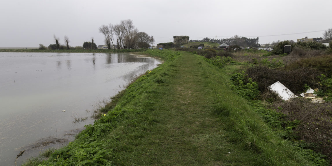
It became clear that, despite the high shingle embankment, the settlement of Pett Level, which nestles on the land side of the embankment is very vulnerable and should the shingle be breached would suffer a devastating flood. Later I took a picture which showed that the high water mark on the seaward side of the embankment was noticeably higher than the land behind the embankment. In fact the land in the picture is higher than the road through the village where most of the houses are built.

This is a village which is below sea level much of the time and protected by an embankment of shingle, a fluid material which is vulnerable to shift during storms.
I also spoke to a group of people who were litter picking the beach (it’s a community minded place). They said that the embankment was constantly replenished with shingle from further east along the coast. The shingle moves eastward under the effect of longshore drift. If intervention stopped, the shingle would move away east, the embankment would be breached and the community would be flooded.
Local people said they “tried not to think about” the danger to their homes. I would suggest that is a coded answer meaning that it concerns them a lot. Further west, maintenance of shingle sea defences at Cuckmere Haven had already been abandoned as cost ineffective. I wondered how long before this decision was made for Pett Level. This beach requires an annual recharge of 30,000 to 40,000 cubic metres of shingle at a cost of over £745,000. (1)

I then travelled further east to Rye Harbour where I discovered that a spring tide was in progress. This provided some unique opportunities.
Areas around the yacht club and lifeboat station do flood at times of spring tide. But the sight of water advancing toward the Bosun’s Cafe and filling the front yard of the yacht club gave a premonition of the floods that were to be expected as sea levels rise. The spring tide provided an opportunity to take pictures of the very things that were being predicted.

I was able to get pictures of the village of Rye Harbour being threatened by rising water and of water rising to surround objects that usually resided on dry land.

When I walked to the mouth of the River Brede, I was struck by a scene that seemed to encompass the dangers faced by this part of Sussex. Natural undulations in the shingle had formed a pool of seawater. There was a breach in the ridge of shingle that separated the pool from the sea. As each new wave came in, water broke through the breach and flooded into the pool. In miniature, here was the danger. A storm would break through the embankment and the sea would flood into the land beyond.

I started the day with the expectation of finding the submerged forest, in itself an interesting site. I kept myself open to new possibilities and discovered much more. A history of the land being under the sea, then reclaimed by engineering, only to be threatened again by the unintended consequences of human activity. I met people living with the everyday reality of losing their homes to the nest big storm. I saw flooded landscapes and communities protected by a modest bank of earth.
During the course of a day, I saw changes to the coastline that had occurred over a period of over 5000 years. I also saw a vision of what is predicted to happen in the future.
(1) University of Sussex – http://www.sussex.ac.uk/geography/researchprojects/BAR/publish/Phase-1-final-Beach%20recharge.pdf